

FlightX - Airport Finder & Flight Plan Calculator

وصف لـFlightX - Airport Finder & Flight Plan Calculator
FlightX is a flight planning tool with an extensive worldwide airfield / airport listing.
It's an ideal application for VFR Pilots to plan a successful trip and cross reference other flight planning calculations.
Create Flight Plans
Find airports and airfields by code, description, or part thereof
Enables the user to create a flight plan
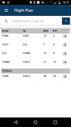
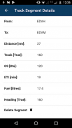
Calculate flight distance, flight times and track information for each flight segment and totals for a multi-stop flight plan
Provide information on airfields such as elevation, latitude, longitude
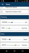
Calculate fuel burn based on burn rate specified
Heading information taking into account specified wind information
Calculating wind correction
The app will adjust existing flight plan calculation if any factor affecting these is adjusted
Find airports, airfields and other information
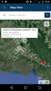
The app can switch between a map view, satellite view, or hybrid view to display flight information.
Flight plan information can be created visually on a map (click the info window), or via the automatic airport / airfield finder lookup. Simply start typing and the app will provide the best match to your search.
Additionally the app can search for closed airfield, registered heliports, seaplane port.
Particularly useful is the feature where the app can find all airfields / airports within a geographical region. Simply zoom in or out on the map, and select Find All Airfields on Map.
Note: that for the Australian region the app also can find VFR waypoints as registered in the EnRouteSupplement.
The app comes with a 30-day trial period, after which time an annual subscription can be purchased through the Google Play Store.
Developed by pilots for pilots.
FlightX هي أداة لتخطيط الرحلات تتضمن قائمة واسعة من المطارات / المطارات في جميع أنحاء العالم.
إنه تطبيق مثالي لبرنامج VFR Pilots للتخطيط لرحلة ناجحة والإحالة المرجعية لحسابات تخطيط رحلات الطيران الأخرى.
إنشاء خطط طيران
ابحث عن المطارات والمطارات حسب الرمز أو الوصف أو جزء منه
يمكّن المستخدم من إنشاء خطة رحلة
حساب مسافة الرحلة وأوقات الرحلات ومعلومات المسار لكل جزء من الرحلات والإجماليات لخطة رحلة متعددة الرحلات
تقديم معلومات عن المطارات مثل الارتفاع وخط العرض وخط الطول
احسب حرق الوقود بناءً على معدل الحرق المحدد
معلومات العنوان مع مراعاة معلومات الرياح المحددة
حساب تصحيح الرياح
سيعدل التطبيق حساب خطة الطيران الحالية إذا تم تعديل أي عامل يؤثر على هذه العناصر
ابحث عن المطارات والمطارات وغيرها من المعلومات
يمكن للتطبيق التبديل بين عرض الخريطة أو عرض القمر الصناعي أو العرض المختلط لعرض معلومات الرحلة.
يمكن إنشاء معلومات خطة الطيران بشكل مرئي على الخريطة (انقر على نافذة المعلومات) ، أو عن طريق البحث التلقائي عن المطارات / المطارات. ببساطة ، ابدأ في الكتابة وسيقدم التطبيق أفضل مطابقة لبحثك.
بالإضافة إلى ذلك يمكن التطبيق البحث عن مطار مغلق ، طائرات الهليكوبتر المسجلة ، ميناء الطائرة المائية.
مفيدة بشكل خاص هي الميزة حيث يمكن التطبيق العثور على جميع المطارات / المطارات داخل المنطقة الجغرافية. ببساطة قم بتكبير الخريطة أو تصغيرها ، وحدد البحث عن جميع المطارات على الخريطة . ملاحظة: أنه بالنسبة للمنطقة الأسترالية ، يمكن أن يجد التطبيق أيضًا نقاط طريق VFR مسجلة في EnRouteSupplement.
يأتي التطبيق مع فترة تجريبية لمدة 30 يومًا ، وبعد ذلك يمكن شراء اشتراك سنوي من خلال متجر Google Play.
طورها طيارون للطيارين


